PRODUCT Design
2023
Autonomous Rover for Land Surveying.

Project Abstract
Purpose is an autonomous rover designed for efficient and precise land surveying across various terrains.
By leveraging LiDAR technology and a tablet-based application, the rover automates data capture and processing, offering a quicker and more accurate survey method. The design process employed Lean UX principles, involving iterative research, prototyping, and user testing to validate hypotheses and refine features. The final solution aims to significantly enhance survey efficiency, reduce time and cost, and integrate seamlessly with existing CAD systems.
Year : 2022
Duration : 3 Months.
Tools : Figma, Miro, Rhino3d, KeyShot, Photoshop, After Effects.
MY ROLE
I was responsible for conducting end-to-end research, identify the opportunity and ideate potential solution to create the best possible intervention to the land surveying technique.
BACKGROUND
A topographical survey measures land to provide detailed data for planning, design, construction, and maintenance projects.
The traditional land surveying process involves setting up instruments, measuring angles and distances, processing data, and creating maps, all of which are time-consuming and labor-intensive.

PROBLEMS WITH THE PROCESS
The current practice of topographical surveying is time-consuming, labor-intensive, and hindered by weather and natural obstacles.

problem statement
The process of topography survey can take a long time and requires a lot of manual work on the site. There are also external factors involved like weather, natural obstacles which hinders the whole process.
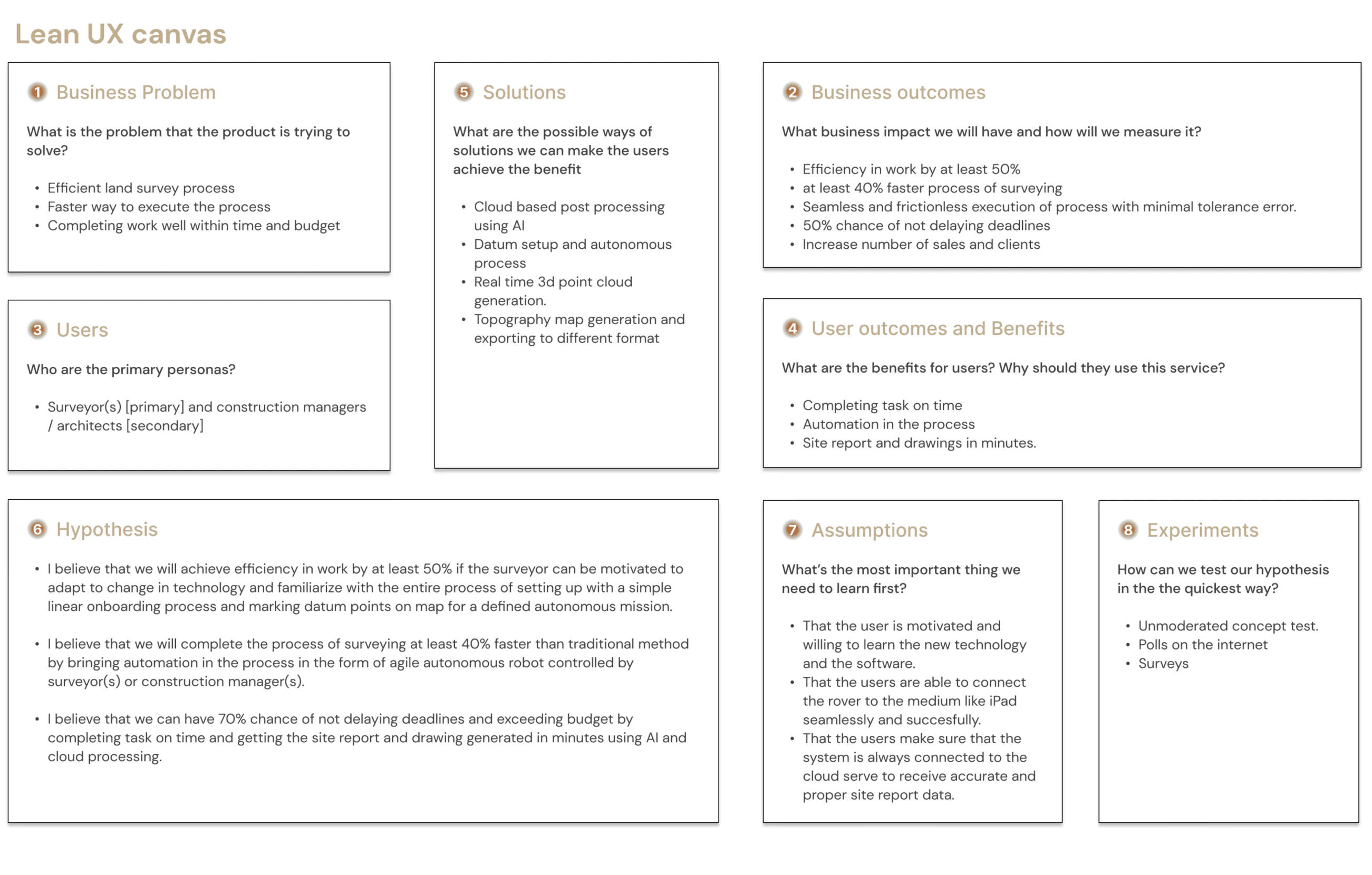
There’s an opportunity to make land surveying quicker, and thus improve the efficiency and pace of surveying.
The SOLUTION
Purpose - an autonomous surveyor
[Purpose] is an agile mobile robot that can navigate through different terrains to capture the geological data of the land using LiDaR technology.
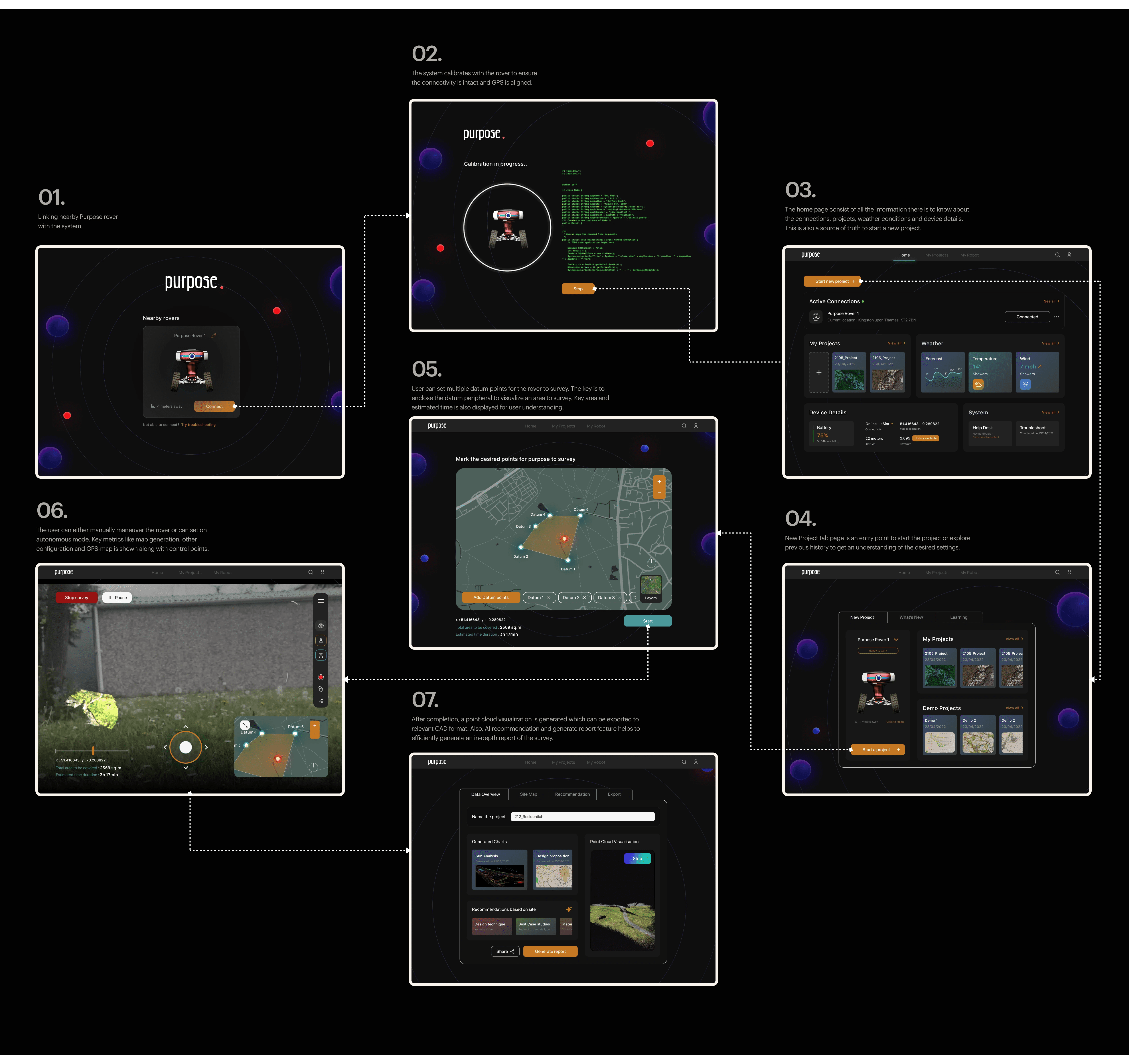
functionality and process
This robot is controlled via a tablet application that processes real-time data and generates overview reports, which can be exported to CAD software for further use.
STEP 1
Setting up
Once the account is registered, User proceeds to sign-in and connect the rover to the app.
STEP 2
Callibration and onboarding
After the rover is connected to the app, a calibration process occurs in the backend to ensure seamless connectivity with the device.
STEP 3
Setting up new project
One can easily set up a new project from the top navigation bar and proceed to establish datum points on the map. A peripheral displacement boundary is digitally created for the area that needs to be surveyed.
STEP 4
Surveying Controls
Utilizing its integrated sensors and LiDAR technology, the rover is capable of autonomously surveying the surface and generating a 3D topographical map that can be exported to various CAD platforms.
PLAN OF ACTION
The design process used Lean UX to ensure rapid, iterative development, allowing for frequent adjustments based on user feedback and real-world testing to create a functional and effective land surveying solution.
As a product that entails building an agile robot as well as a software application, this project was based on a four-step framework: Research, Technology, Prototyping, And Testing.
TARGET AUDIENCE
I identified that company with in-house team of surveyors and construction managers and architecture firm who often depend on the outsourced report of surveyors are my Serviceable Available Market (SAM).
research and assumptions
Based on the problem, it was necessary to brainstorm ideas and thoughts to solve it using assumption mapping.
These assumptions, based on relevant questions, allowed us to gain a comprehension of many attributes and characteristics of the business and user goals and issues, as well as to give an idea about who we are developing the product for.

affinity mapping
The analysis indicated a market need for an automated surveying tool for professionals, prioritizing features like autonomous calculations, cloud processing, and data visualization.

initial hypothesis
Directing the process ahead
It was important to facilitate and drive the process with an initial hypothesis after establishing the project's goals and objectives and keeping the assumptions and problem statement in mind.
“We believe that building an agile mobile robot for conducting topography survey will help automate the entire topography survey process, thus making it possible for land surveying to be cost efficient, quick, and easy irrespective of any external factors.”
primary research
Positive feedback from 2 users strengthened the case and validated the hypothesis.
A total of two interactions with prospective users were conducted (email interaction with surveying agency and user interview with construction manager).
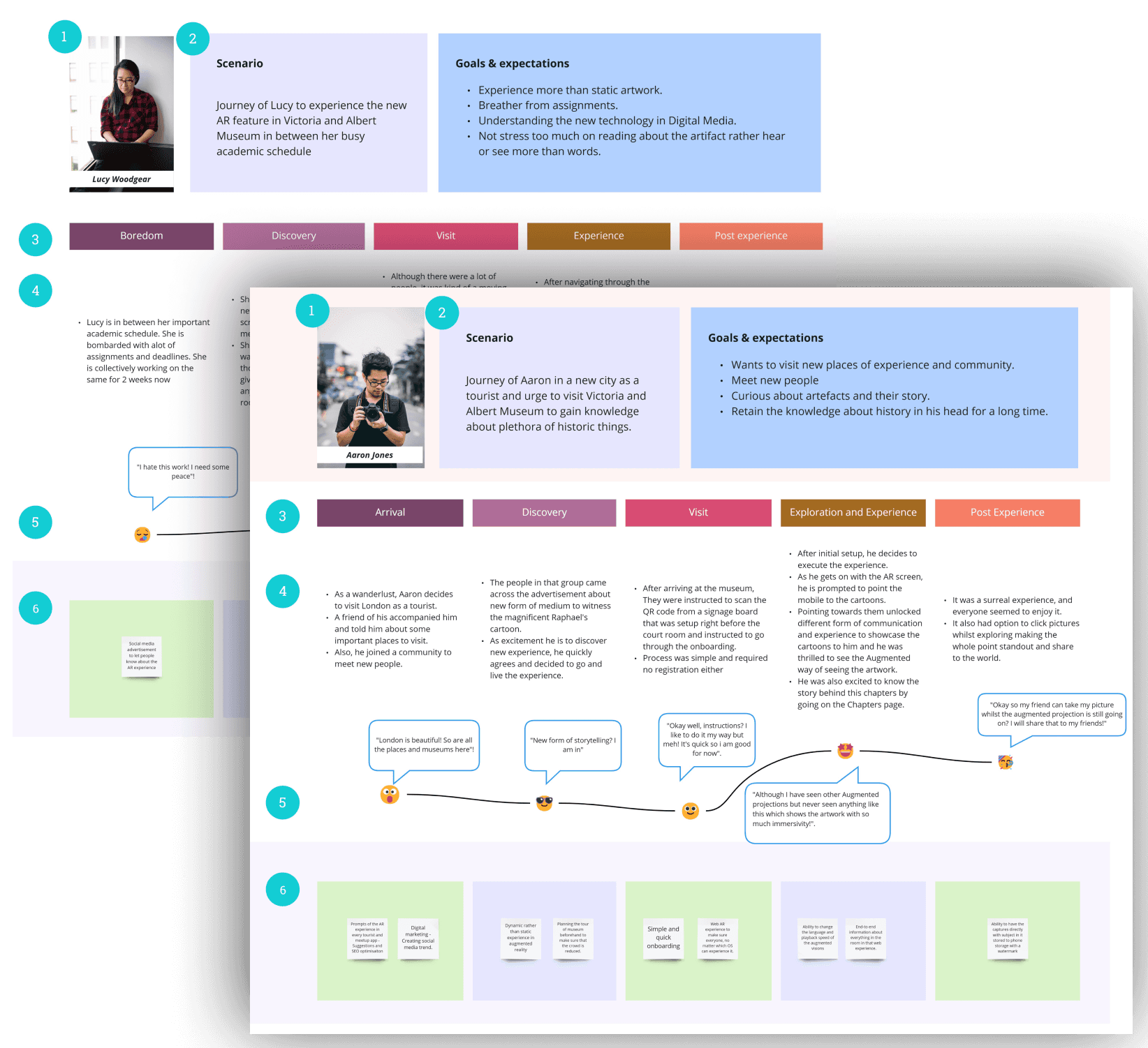
To-be customer journey
The journey map was created after analyzing findings from persona, assumptions, and research to understand the context in which the user would interact with the product based on a scenario. This step aided in identifying gaps in the user flow and paved the way for opportunities and solutions to close those gaps.
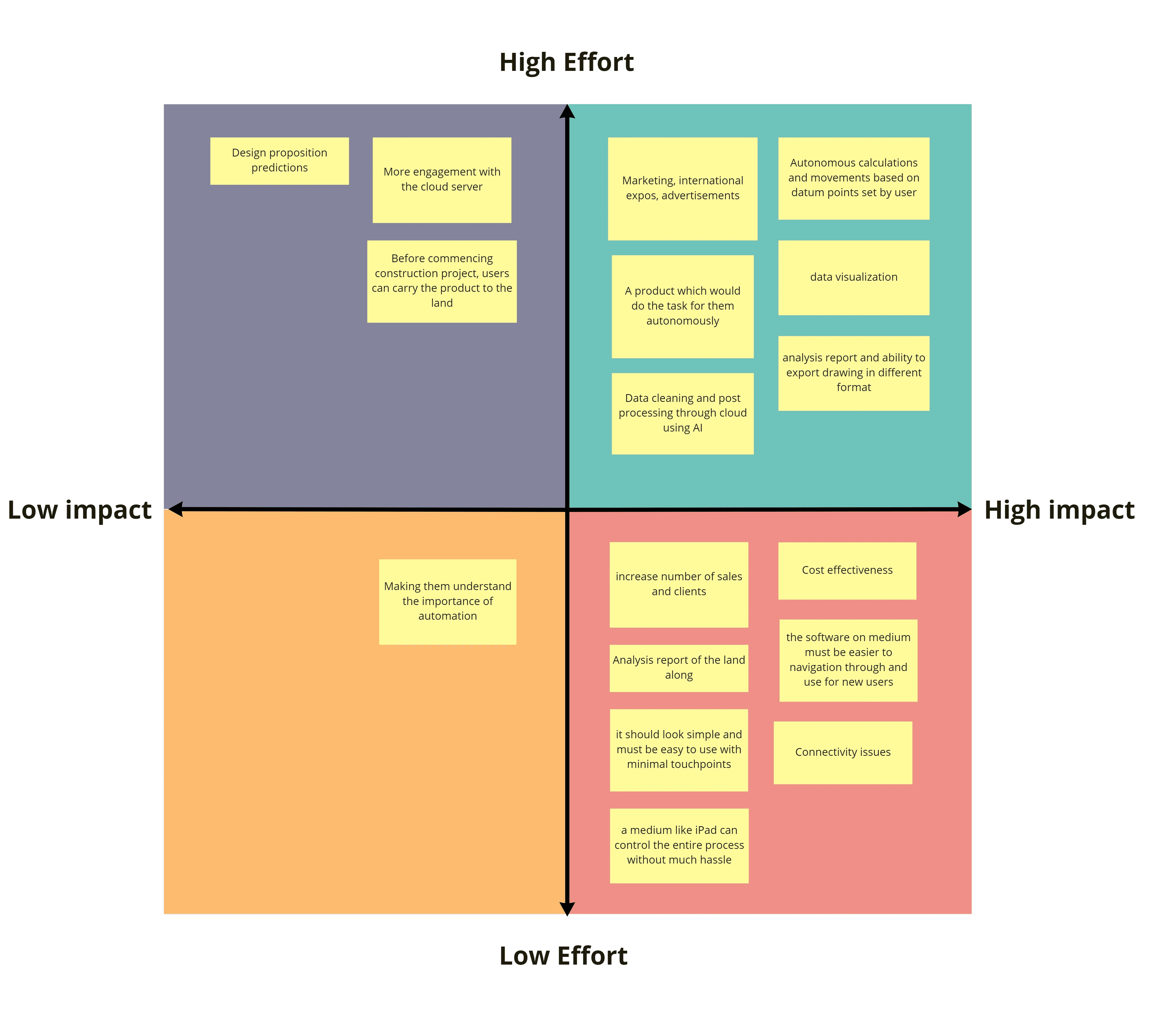
feature prioritizing
What are the must-haves?
Based on the solutions and ideas obtained in the previous stages, it was required to pick a few viable solutions that would have a significant impact on the product.
On that premise, a Bull's eye chart was utilised to divide the concepts into three primary divisions based on relevance and utility.
These suggestions were then prioritised again using the MoSCoW method based on the significant benefits a feature could provide in the shortest amount of time.

Priorities on the basis of feasibility, effort and impact.
Following are some of the Must Have features which were prioritized using the above-mentioned charts:
Cloud based post processing using AI
Datum (boundary marking) setup and autonomous process
Analysis report
Linear onboarding process
Topography map generation and exporting to different format
Robust wheels
Sensors
The HYPOTHESIS STATEMENTS
Laying a solid path
As the features were prioritised and the business and user outcomes were determined, it was critical to combine them and develop final hypothesis statement(s) for the project at this point.
IDEATION
Understanding the service flow of the system
Based on a card sorting activity done with a user and designer, a user flow diagram was created to map the product's flow and analyze the efficiency of the process.


rover design
Designing the rover
The final design model was created after a series of iterations and brainstorming processes. The goal of creating something friendly, portable, and useful was met. The prototype of the rover was modelled in 3D modelling programme Rhinoceros3d and then rendered in Keyshot to make it look as authentic as possible to inform users and designers about the scale, aesthetics, and how it stands in the environment.

Several simulations were run to test the balance and robustness parameters.

rover design
Technology implemented


user interface designs of ipad app
Sketching it out
The Lo-Fi paper sketches were designed to understand how the UI screen will look after using the 6-up rapid ideation process and keeping the user flow in mind.

FINAL DESIGNS
Drivin' the rover with ease.
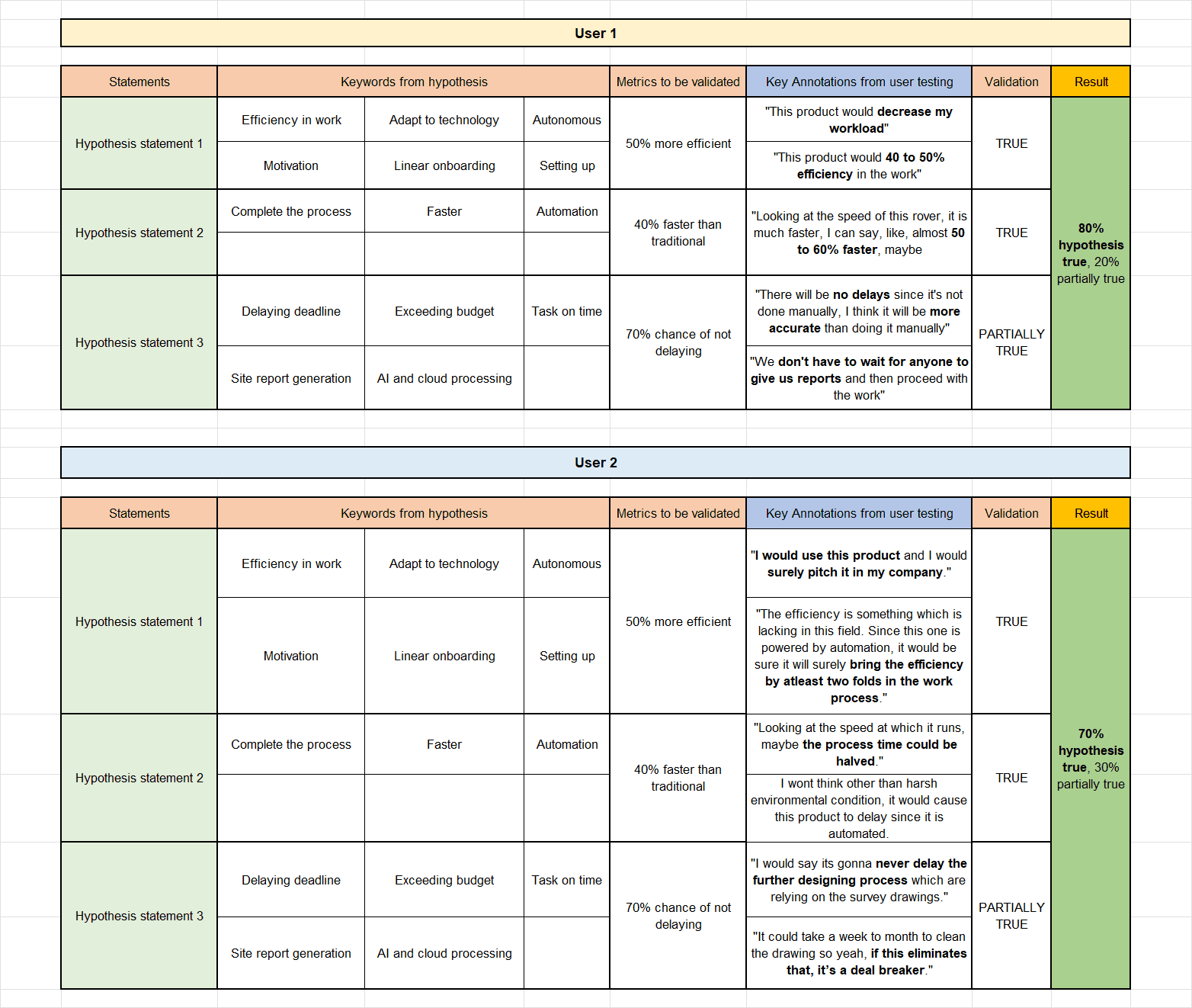
user testing
Evaluating usability with the users.
The product was analysed and tested with real users during the testing process. Formative evaluation assessment was conducted to test the product and check if the hypothesis statements are valid or not.
The evaluation results were deemed positive with only minimal iterations.
looking back
My Reflections
Although an academic project, this project helped me understand the value of 'assumption-first' approach, something that most companies do nowadays and deploy the MVP as soon as possible to get real insights.
The whole idea of Lean UX is to deploy a real MVP in the market to see its market fit as quick as possible. But to drive a successful release, it is key to define the right problem and hypothesis to get the desired outcome, failing which could derail the entire journey and eventually business.
Next project